
Keyword
glaciers
24 record(s)
Type of resources
Available actions
Topics
Keywords
Contact for the resource
Provided by
Formats
Representation types
Update frequencies
Status
Scale
-
In the mountain regions of the Hindu Kush, Karakoram and Himalaya (HKH)the “third polar ice cap” of our planet, glaciers play the role of “water towers” by providing significant amount of melt water, especially in the dry season, essential for agriculture, drinking purposes, and hydropower production. Recently, most glaciers in the HKH have been retreating and losing mass, mainly due to significant regional warming, thus calling for assessment of future water resources availability for populations down slope. However, hydrology of these high altitude catchments is poorly studied and little understood. Most such catchments are poorly gauged, thus posing major issues in flow prediction therein, and representing in fact typical grounds of application of PUB concepts, where simple and portable hydrological modeling based upon scarce data amount is necessary for water budget estimation, and prediction under climate change conditions. In this preliminarily study, future (2060) hydrological flows in a particular watershed (Shigar river at Shigar, ca. 7000 km2), nested within the upper Indus basin and fed by seasonal melt from major glaciers, are investigated. The study is carried out under the umbrella of the SHAREPaprika project, aiming at evaluating the impact of climate change upon hydrology of the upper Indus river. We set up a minimal hydrological model, tuned against a short series of observed ground climatic data from a number of stations in the area, in situ measured ice ablation data, and remotely sensed snow cover data. The future, locally adjusted, precipitation and temperature fields for the reference decade 2050– 2059 from CCSM3 model, available within the IPCC’s panel, are then fed to the hydrological model. We adopt four different glaciers’ cover scenarios, to test sensitivity to decreased glacierized areas. The projected flow duration curves, and some selected flow descriptors are evaluated. The uncertainty of the results is then addressed, and use of the model for nearby catchments discussed. The proposed approach is valuable as a tool to investigate the hydrology of poorly gauged high altitude areas, and to project forward their hydrological behavior pending climate change.
-

The research project SHARE PAPRIKA is devoted to determining the state of glaciers and water resources in the Hindu-Kush Karakorum Himalaya region (HKKH) and to estimating their conditions in the coming decades in different climate change scenarios. PAPRIKA included the twin national projects: PAPRIKA-Italy and PAPRIKA-France, having two different focus areas. The main focus area of PAPRIKA-Italy was the Karakorum region, in particular the Baltoro glacier and the upper Indus basin in Northern Pakistan. Another focus of PAPRIKA-Italy was the Changri Nup glacier area, lying on lateral valley of the Khumbu region in Nepal.
-

As regards glaciers, in the park 50 ice bodies are present covering about 40 km2. Among the others, Forni, at 12 km2 of area the largest Italian valley glacier. Its recent changes underlined a strong relation with regional and global climate evolution (Pelfini & Smiraglia, 1997; Smiraglia et al., 2007; Smiraglia et al., 2008); in addition this glacier was also inserted in the GOSITES list (Diolaiuti & Smiraglia, 2010), a list including all the geomorphological systems to be protected due to their high scientific, environmental and aesthetic values. On Forni Glacier since 2005 has been running the first Italian supraglacial automatic weather station (Citterio et al., 2007). The data collected were useful to model glacier energy and mass exchanges and to describe local micro-meteorology (Diolaiuti at al., 2009; Senese et al., 2010). Not only large glaciers are important for environmental studies; in fact, in the Park also smaller ones revealed important information.
-
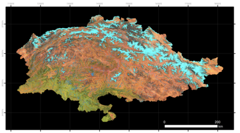
Sentinel-2 RGB composite image of the Pakistan region used in this inventory. This image is the synthesis of all the images acquired by the Sentinel-2 satellites in the period “2022-07-31" -"2022-10-01. In the Red, Green and Blue channels the SWIR, NIR and Red bands are represented. The main land cover types can be identified: in bright blue the snow, in dark blue the ice, in bright and dark tones of red the bare soils and rocks, and in green the vegetated areas.
-
In the framework of PAPRIKA-italy specific activities were performed to monitoring the quality of water originating from the Karakoram glaciers. Four dedicated hydrological campaigns were performed to assess the quality an quantity of water; in April and July 2011, May 2012 and April 2013. Two permanent hydrometric stations were installed in two key sites, the Shigar Bridge and Paju, providing continuous measurements of water level and hanse, discharge activity and water chemistry.
-
This new Pakistan glacier inventory has been extracted from optical data acquired by the European Space Agency Sentinel-2 twin satellites. This choice is dictated by the need to respond to the requirement to have homogeneous coverage of the entire territory under examination in terms of image acquisition dates, cloud cover and good spatial resolution, that allow the recognition of glaciers and their mapping. Furthermore, particular attention in the selection of the data processing and mapping methods was given for the expected prospect activity of updating the glacial perimeters and monitoring changes in the future. The methodology was based on a semi-automatic classification (segmentation) and the mapping has been implemented in a Geographic Information System (GIS) environment. In this new inventory, 13,032 glaciers covering 13,546.93 km2 have been mapped. The available inventory is the Version 1.0.
-
In the framework of PAPRIKA-italy specific activities were performed to monitoring the quality of water originating from the Karakoram glaciers. Four dedicated hydrological campaigns were performed to assess the quality an quantity of water; in April and July 2011, May 2012 and April 2013. Two permanent hydrometric stations were installed in two key sites, the Shigar Bridge and Paju, providing continuous measurements of water level and hanse, discharge activity and water chemistry.
-
One of the most important results of Glaciers & Students Project is the publication of the book that describes the activities end the methods adopted for the recognition and mapping of the 13,032 glaciers in Pakistan in the three ranges of Himalaya, Karakorum and Hindukush. The analysis of the satellite of 2022 gives a precise delineation of the surface of the glaciers and gives the possibility to verify the trend that happened in the last 30 years comparing the previous inventory with the new one. The knowledge of the places that host the glaciers of Pakistan is presented in this book with a series of maps of the 62 basins that occupy the Northern areas of Pakistan. The maps are published with scales aimed at a clear representation of the glacier distribution in each basin. To facilitate the recognition of glaciers in some wide basins, the zoom panels represented in the boxes were produced at the most suitable scale.
-
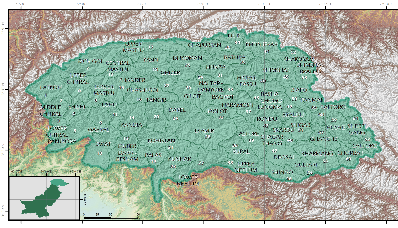
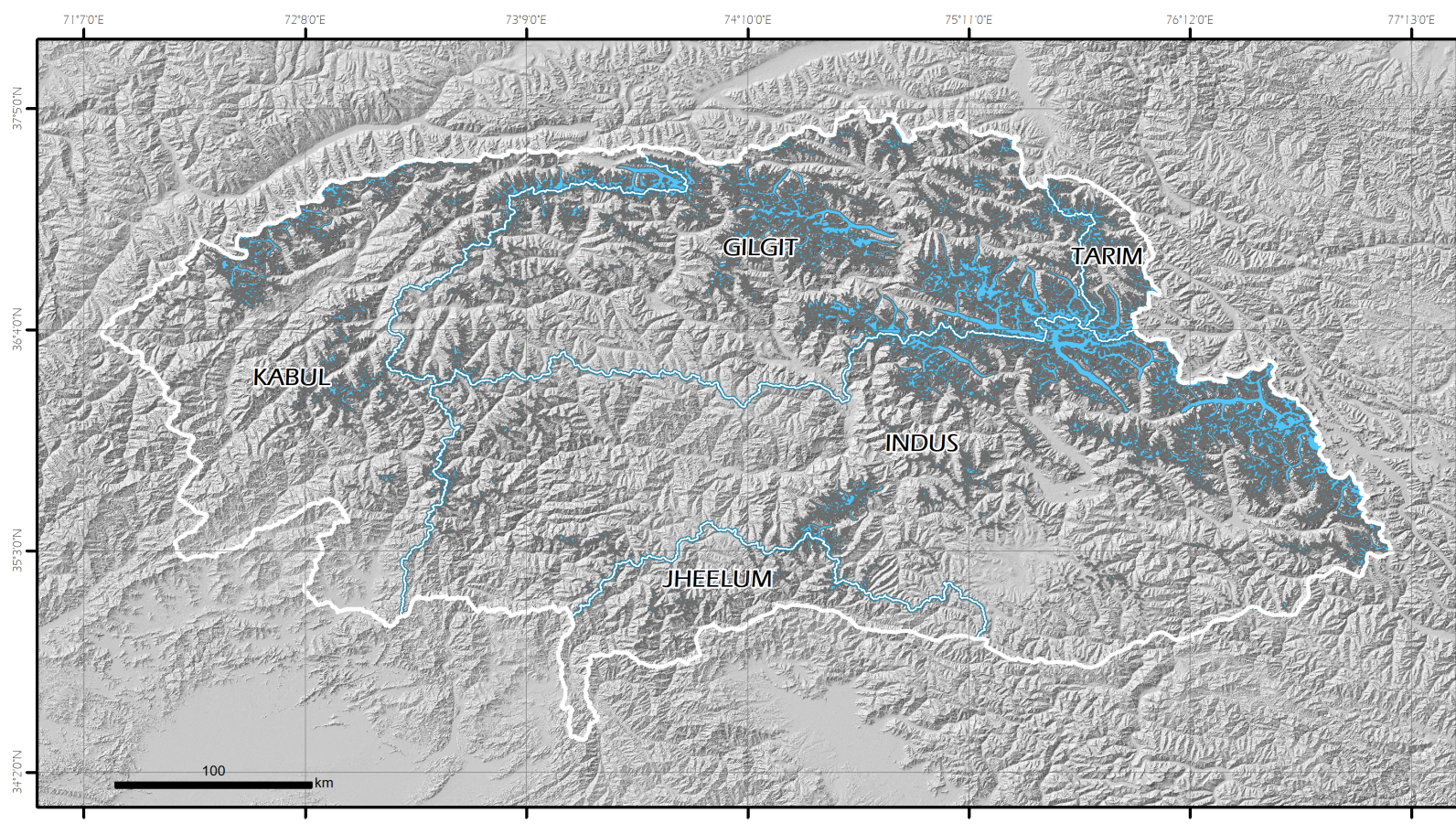
In this project, tin order to facilitate the recognition of the glaciers, the region has been divided in hydrographical basins. These basins have been extracted from the DEM ALOS AW3D30 global DEM, at 30 m spatial resolution. The region has been divided in 62 basins.
-
Glaciers & Students project aims at developing a consolidating program to establish monitoring of high altitude climate and assessment of glacier changes, in support of environmental monitoring and natural resources management in Pakistan Mountains, Project activities will also contribute to improve risk assessment and prevention, dealing in particular with GLOFs and hydrogeological hazard, thanks to the application of remote sensing and GIS techniques and a dedicated web information system. The project intends to actively involve Pakistan Universities and their students in the monitoring activities through a dedicated training and capacity building program in the field of glaciers monitoring activities and remote sensing analysis in order to provide the appropriate tools to ensure the pursuing of a long term research activities at the end of the project. The responsible of the funds was UNDP Pakistan. EvK2CNR Pakistan has been the reference partner of this project and the universities of Milan and Cagliari have been involved for the execution of the activities. The final products of the projects are: - the new glaciers inventory in shape format; - the text with the presentation of this new output and the single maps of each basin.