
Keyword
hydrology
5 record(s)
Type of resources
Available actions
Topics
Keywords
Contact for the resource
Provided by
Years
Formats
Representation types
Update frequencies
Status
Scale
-
In the mountain regions of the Hindu Kush, Karakoram and Himalaya (HKH)the “third polar ice cap” of our planet, glaciers play the role of “water towers” by providing significant amount of melt water, especially in the dry season, essential for agriculture, drinking purposes, and hydropower production. Recently, most glaciers in the HKH have been retreating and losing mass, mainly due to significant regional warming, thus calling for assessment of future water resources availability for populations down slope. However, hydrology of these high altitude catchments is poorly studied and little understood. Most such catchments are poorly gauged, thus posing major issues in flow prediction therein, and representing in fact typical grounds of application of PUB concepts, where simple and portable hydrological modeling based upon scarce data amount is necessary for water budget estimation, and prediction under climate change conditions. In this preliminarily study, future (2060) hydrological flows in a particular watershed (Shigar river at Shigar, ca. 7000 km2), nested within the upper Indus basin and fed by seasonal melt from major glaciers, are investigated. The study is carried out under the umbrella of the SHAREPaprika project, aiming at evaluating the impact of climate change upon hydrology of the upper Indus river. We set up a minimal hydrological model, tuned against a short series of observed ground climatic data from a number of stations in the area, in situ measured ice ablation data, and remotely sensed snow cover data. The future, locally adjusted, precipitation and temperature fields for the reference decade 2050– 2059 from CCSM3 model, available within the IPCC’s panel, are then fed to the hydrological model. We adopt four different glaciers’ cover scenarios, to test sensitivity to decreased glacierized areas. The projected flow duration curves, and some selected flow descriptors are evaluated. The uncertainty of the results is then addressed, and use of the model for nearby catchments discussed. The proposed approach is valuable as a tool to investigate the hydrology of poorly gauged high altitude areas, and to project forward their hydrological behavior pending climate change.
-

The research project SHARE PAPRIKA is devoted to determining the state of glaciers and water resources in the Hindu-Kush Karakorum Himalaya region (HKKH) and to estimating their conditions in the coming decades in different climate change scenarios. PAPRIKA included the twin national projects: PAPRIKA-Italy and PAPRIKA-France, having two different focus areas. The main focus area of PAPRIKA-Italy was the Karakorum region, in particular the Baltoro glacier and the upper Indus basin in Northern Pakistan. Another focus of PAPRIKA-Italy was the Changri Nup glacier area, lying on lateral valley of the Khumbu region in Nepal.
-
In the framework of PAPRIKA-italy specific activities were performed to monitoring the quality of water originating from the Karakoram glaciers. Four dedicated hydrological campaigns were performed to assess the quality an quantity of water; in April and July 2011, May 2012 and April 2013. Two permanent hydrometric stations were installed in two key sites, the Shigar Bridge and Paju, providing continuous measurements of water level and hanse, discharge activity and water chemistry.
-
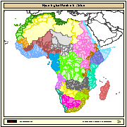
Major hydrological basins and their sub-basins. This dataset divides the African continent according to its hydrological characteristics. The dataset consists of the following information:- numerical code and name of the major basin (MAJ_BAS and MAJ_NAME); - area of the major basin in square km (MAJ_AREA); - numerical code and name of the sub-basin (SUB_BAS and SUB_NAME); - area of the sub-basin in square km (SUB_AREA); - numerical code of the sub-basin towards which the sub-basin flows (TO_SUBBAS) (the codes -888 and -999 have been assigned respectively to internal sub-basins and to sub-basins draining into the sea)
-
In the framework of PAPRIKA-italy specific activities were performed to monitoring the quality of water originating from the Karakoram glaciers. Four dedicated hydrological campaigns were performed to assess the quality an quantity of water; in April and July 2011, May 2012 and April 2013. Two permanent hydrometric stations were installed in two key sites, the Shigar Bridge and Paju, providing continuous measurements of water level and hanse, discharge activity and water chemistry.