
Keyword
water resources
7 record(s)
Type of resources
Available actions
Topics
Keywords
Contact for the resource
Provided by
Years
Formats
Representation types
Update frequencies
Status
Scale
-

The research project SHARE PAPRIKA is devoted to determining the state of glaciers and water resources in the Hindu-Kush Karakorum Himalaya region (HKKH) and to estimating their conditions in the coming decades in different climate change scenarios. PAPRIKA included the twin national projects: PAPRIKA-Italy and PAPRIKA-France, having two different focus areas. The main focus area of PAPRIKA-Italy was the Karakorum region, in particular the Baltoro glacier and the upper Indus basin in Northern Pakistan. Another focus of PAPRIKA-Italy was the Changri Nup glacier area, lying on lateral valley of the Khumbu region in Nepal.
-
In the framework of PAPRIKA-italy specific activities were performed to monitoring the quality of water originating from the Karakoram glaciers. Four dedicated hydrological campaigns were performed to assess the quality an quantity of water; in April and July 2011, May 2012 and April 2013. Two permanent hydrometric stations were installed in two key sites, the Shigar Bridge and Paju, providing continuous measurements of water level and hanse, discharge activity and water chemistry.
-

"Mountain lakes of high altitude (Himalaya)" in Long Term Ecological Research Network-Italy Location: Lat 27 ° 57'54 "N Long 86 ° 48'40" E; Lake Area (m2): 5.7 103: Average depth(m): unknown; Maximum depth (m): 8.2; Altitude of the lake (m): 5213; Area Region: Himalayas, Khumbu Valley, Mount Everest.
-

"Mountain lakes of high altitude (Himalaya)" in Long Term Ecological Research Network-Italy Location: Lat 27 ° 57'45 "N Long 86 ° 48'56" E; Lake Area (m2): 16.7 103: Average Depth (m): unknown; Maximum depth (m): 8.2; Altitude of the lake (m asl): 5067; Region: Himalayas, Khumbu Valley, Mount Everest.,
-
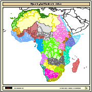
Major hydrological basins and their sub-basins. This dataset divides the African continent according to its hydrological characteristics. The dataset consists of the following information:- numerical code and name of the major basin (MAJ_BAS and MAJ_NAME); - area of the major basin in square km (MAJ_AREA); - numerical code and name of the sub-basin (SUB_BAS and SUB_NAME); - area of the sub-basin in square km (SUB_AREA); - numerical code of the sub-basin towards which the sub-basin flows (TO_SUBBAS) (the codes -888 and -999 have been assigned respectively to internal sub-basins and to sub-basins draining into the sea)
-
In the framework of PAPRIKA-italy specific activities were performed to monitoring the quality of water originating from the Karakoram glaciers. Four dedicated hydrological campaigns were performed to assess the quality an quantity of water; in April and July 2011, May 2012 and April 2013. Two permanent hydrometric stations were installed in two key sites, the Shigar Bridge and Paju, providing continuous measurements of water level and hanse, discharge activity and water chemistry.
-

People in the Karakoram use discharge from glaciers during summer for irrigation and other purposes. While the glacial meltwater supply during hot and dry periods will vary as a result of climate change, Karakoram glaciers so far have not shown a consistent reaction to climatic change, although climate scenarios indicate severe future impacts in the high-elevation regions of the Himalaya and Karakoram. Field measurements on Hinarche Glacier in Bagrot Valley are combined with remote sensing information and climate observations to investigate the meltwater production of the glacier and estimate the meltwater discharge in the valley. Special emphasis was placed on ice melt beneath supraglacial debris, which is the common process on the glacier tongues in the region. The calculated annual meltwater production of about 135 million m3 for Hinarche Glacier shows the order of magnitude for glacier runoff in such environments. Glacial meltwater production is about 300 million m3 per year for the entire valley under balanced conditions. This analysis serves as a basis for further investigations concerning temporal meltwater variability and potential water usage by the local population.