
Keyword
Inland waters
8 record(s)
Type of resources
Available actions
Topics
Keywords
Contact for the resource
Provided by
Years
Formats
Representation types
Update frequencies
Status
Scale
-

The purpose of the present work was to investigate variations in the surface areas of lakes in the north-east sector of Sagarmatha National Park (Nepal) at the end of the 20th century, through comparison of the Mount Everest maps based on a survey done in the early 1980s, and the official Map of Nepal based on a survey done at the beginning of the 1990s. The analysis of the changes occurring between the 1980s and the 1990s in the surface areas and distribution of lakes in the north-east sector of SNP reveals that lake areas substantially increased, by 15.4 (-5.5; +5.7)% (median 12.5%), within hydrographic basins that included a certain amount of glacial cover. In fact, 96% of the lakes whose surface area increased are located in glacial basins. Conversely, the majority of the lakes without glacial cover in their catchment showed a reduction in surface area, and in many cases disappeared (83% of the lakes that disappeared were situated in basins without glaciers). This different behaviour of these two types of lakes, though observed over a short time span, would appear to be consistent with the consequences of temperature increases recorded from the beginning of 1980s on a global and local scale. The digital tool produced (Limnological Information System, LIS) as part of this work is intended to provide a useful platform for extending the analysis to entire area of SNP, as well as for subsequent comparisons based on earlier maps or more recent satellite images.
-

The most remote regions of the globe are home of the least disturbed ecosystems, yet they are threatened by air pollution and by climatic change. The Himalayas are one of the most isolated and least explored wilderness areas in the world outside the Polar Regions and it is for this reason that the Tibetan Plateau is often referred to as the Third Pole. Since 1990, an annual limnological survey (including chemistry and biology) has been carried out at two lakes located in the Kumbhu Valley, Nepal, at 5200 and 5400m a.s.l., respectively. Lake water chemistry surveys reveal a persistent increase in the ionic content of the lake water, a trend which appears to be closely linked to increasing temperature. In this study, we also analysed lake sediment cores for historical changes in algal abundance and community composition to evaluate how long-term variations in primary producer communities corresponded to known regional variations in climate systems during the past 3500years. Paleolimnological results support the evidence that the strong variability observed in the chemical data drives the variability in lake production and in the composition of algal assemblages. These variabilities can be related to known features of local climate and the values recorded in the recent years compare well with those recorded during warm periods, such as around 2000 BP, and thus support the idea that this area of the Himalayan Range, influenced by the South Asia monsoon, is closely linked to Northern Hemisphere climate dynamics.
-

"Mountain lakes of high altitude (Himalaya)" in Long Term Ecological Research Network-Italy Location: Lat 27 ° 57'54 "N Long 86 ° 48'40" E; Lake Area (m2): 5.7 103: Average depth(m): unknown; Maximum depth (m): 8.2; Altitude of the lake (m): 5213; Area Region: Himalayas, Khumbu Valley, Mount Everest.
-

"Mountain lakes of high altitude (Himalaya)" in Long Term Ecological Research Network-Italy Location: Lat 27 ° 57'45 "N Long 86 ° 48'56" E; Lake Area (m2): 16.7 103: Average Depth (m): unknown; Maximum depth (m): 8.2; Altitude of the lake (m asl): 5067; Region: Himalayas, Khumbu Valley, Mount Everest.,
-
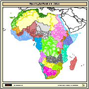
Major hydrological basins and their sub-basins. This dataset divides the African continent according to its hydrological characteristics. The dataset consists of the following information:- numerical code and name of the major basin (MAJ_BAS and MAJ_NAME); - area of the major basin in square km (MAJ_AREA); - numerical code and name of the sub-basin (SUB_BAS and SUB_NAME); - area of the sub-basin in square km (SUB_AREA); - numerical code of the sub-basin towards which the sub-basin flows (TO_SUBBAS) (the codes -888 and -999 have been assigned respectively to internal sub-basins and to sub-basins draining into the sea)
-

The most remote regions of globe represent some of the least disturbed ecosystems, yet they are threatened by air pollution and by climatic change. The Himalaya is one of the most isolated regions in the world and least explored wildernesses outside the Polar Regions; and it is for this reason that the Tibetan Plateau is often referred to as the ‘Third Pole’. Limnological survey (including chemistry, biology and sediment core studies) of lakes located between ca. 4500 and 5500 m a.s.l. has been performed from 1992 in the Kumbhu Valley, Nepal. Lake water chemical surveys reveal a constant increase of the ionic content of the lake water probably related to glacier retreat. Modern phytoplankton data compared with previous data point to an increasing trend in lake productivity. Zooplankton, benthos and thechamoebians provide useful biogeographical information. Paleolimnological reconstructions show the potential use of these sites in providing proxy data of past climatic changes in high altitude regions. Data collected of persistent organic pollutants show that the studied sites receive input related to long-range transport pollution. The aims and rationale for the future development of the Ev-K2-CNR Limnological Information System is discussed.
-

In the mountain regions of the Hindu Kush, Karakoram and Himalaya (HKH) the "third polar ice cap" of our planet, glaciers play the role of "water towers" by providing significant amount of melt water, especially in the dry season, essential for agriculture, drinking purposes, and hydropower production. Recently, most glaciers in the HKH have been retreating and losing mass, mainly due to significant regional warming, thus calling for assessment of future water resources availability for populations down slope. However, hydrology of these high altitude catchments is poorly studied and little understood. Most such catchments are poorly gauged, thus posing major issues in flow prediction therein, and representing in facts typical grounds of application of PUB concepts, where simple and portable hydrological modeling based upon scarce data amount is necessary for water budget estimation, and prediction under climate change conditions. In this preliminarily study, future (2060) hydrological flows in a particular watershed (Shigar river at Shigar, ca. 7000 km2), nested within the upper Indus basin and fed by seasonal melt from major glaciers, are investigated. The study is carried out under the umbrella of the SHARE-Paprika project, aiming at evaluating the impact of climate change upon hydrology of the upper Indus river. We set up a minimal hydrological model, tuned against a short series of observed ground climatic data from a number of stations in the area, in situ measured ice ablation data, and remotely sensed snow cover data. The future, locally adjusted, precipitation and temperature fields for the reference decade 2050–2059 from CCSM3 model, available within the IPCC's panel, are then fed to the hydrological model. We adopt four different glaciers' cover scenarios, to test sensitivity to decreased glacierized areas. The projected flow duration curves, and some selected flow descriptors are evaluated. The uncertainty of the results is then addressed, and use of the model for nearby catchments discussed. The proposed approach is valuable as a tool to investigate the hydrology of poorly gauged high altitude areas, and to project forward their hydrological behavior pending climate change.
-

Zooplankton species have evolved several adaptive strategies to minimize damage caused by exposure to solar ultraviolet radiation, but the environmental conditions favoring one strategy or another are not yet fully understood. Here, I quantified the concentration of photoprotective compounds (carotenoids and mycosporine-like amino acids or MAAs) and assessed the photorepair activity (photolyase assay) in populations of the calanoid copepod, Arctodiaptomus jurisowitchi and the cladocerans, Daphnia himalaya and D. longispina, from five high altitude lakes located in the Himalayan Region (Khumbu Valley, Nepal) between 4890 and 5440 m above sea level. The concentration and diversity of MAAs were low in copepods, as well as in seston samples. Significant differences in the concentration of MAAs among the five copepod populations were largely explained (96%) by the lake depth refuge (i.e., the fraction of the water column to which 1% of the surface UVR at 320 nm penetrates). Concentrations of carotenoids (mostly free astaxanthin) in copepods were among the highest reported in the literature. Similar to MAAs, the carotenoid concentration was inversely related to the lake depth refuge. The lowest concentration of photoprotective compounds in copepods was observed in a turbid glacier lake, whereas the highest was found in a shallow water body dominated by a benthic mat of filamentous green algae. Except for the presence of melanin in D. himalaya, no other photoprotective compounds were found in cladocerans. The assay of photolyase activity in A. jurisowitchi and D. himalaya suggested the absence of a photorepair mechanism. The results of this study indicate that the copepod populations from this relatively pristine alpine region rely mainly on the accumulation of carotenoids to minimize damage by UV radiation, a pattern that strongly contrasts with what is known for copepods from other alpine lakes, for instance, in the Alps. I hypothesize that this difference is attributed to nitrogen limitation of the MAA synthesis in phytoplankton from remote Himalayan lakes.