
Keyword
Maps
10 record(s)
Type of resources
Available actions
Keywords
Contact for the resource
Provided by
Formats
Representation types
Update frequencies
Status
Scale
-
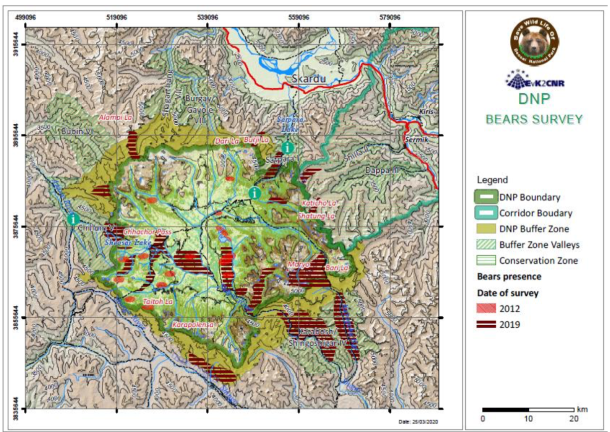
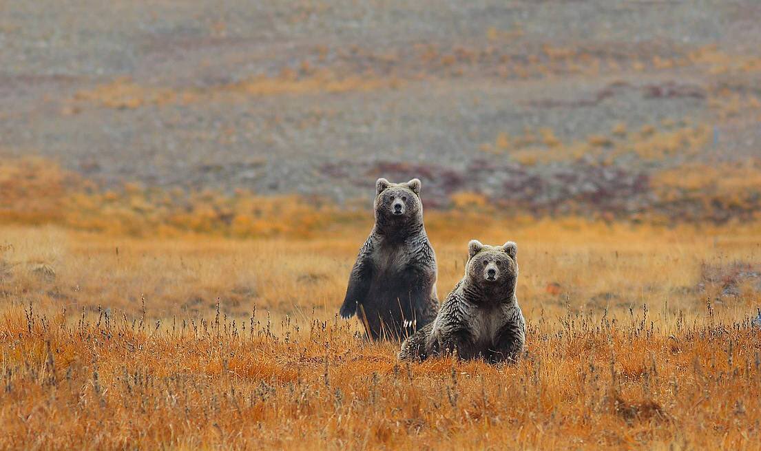
The Himalayan Brown bear is a highly threatened species in Pakistan. Its population is sparse and scattered throughout the Gilgit-Baltistan, KPK and AJK. The largest population in South Asia has been recorded in the Deosai National Park and their current population is more than 88 individuals, which indeed is quite below the minimum viable population size established by past researchers
-
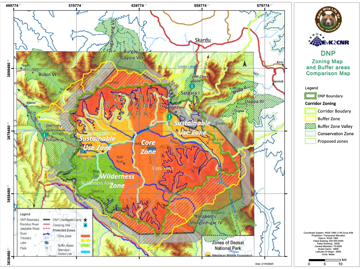
In this Management Plan the boundaries has been delineated with more accuracy and the surface of the Park is 1621.66, 360.34 Km2 less, but if we include the Buffer Zone and the Buffer Zone Valleys the total surface is 3000.7 Km2, almost the same of the proposed surface declared in 1993 at the first declaration of DNP National Park. The difference between the surface of this map and the surface that is delineated in this plan is mainly concentrated in the SE side of the Park where it was not designed on the boundary pillars of Bari-La, but more down in the valleys. The map above is not correct also in the watersheds border especially on the N side, that delimitate the Deosai plateau and has been corrected on the basis of the GIS data, the survey of our and DNP staff, starting from the existing pillars. In these differences, there is the difference in the Core Zone area that is virtually reduced, but it is partially more extended than before or covered with a strict Buffer Zone.
-
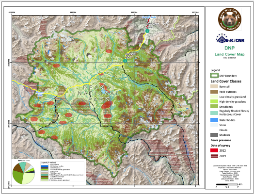
The Land Cover of the DNP map has been obtained from ESA Sentinel-2 imagery. The image used for the interpretation and final classification has been chosen on the basis of phenological state of the vegetation and cloud cover percentage. Moreover, in areas without deciduous vegetation or major seasonal crop variations, one month might suffice. Considering these conditions, a single multispectral image acquired on August 06 2018 has been used. In order to classify the remote sensing image (Sentinel-2), a supervised classification approach using the maximum likelihood (ML) classification algorithm was applied. MLC is a widely used pixel-based, parametric classifier based on the Bayes theorem. It makes use of a discriminant function to assign pixel to the class with the highest likelihood.
-
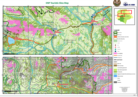
These pictures are the proposed touristic sites with some facilities in the DNP
-
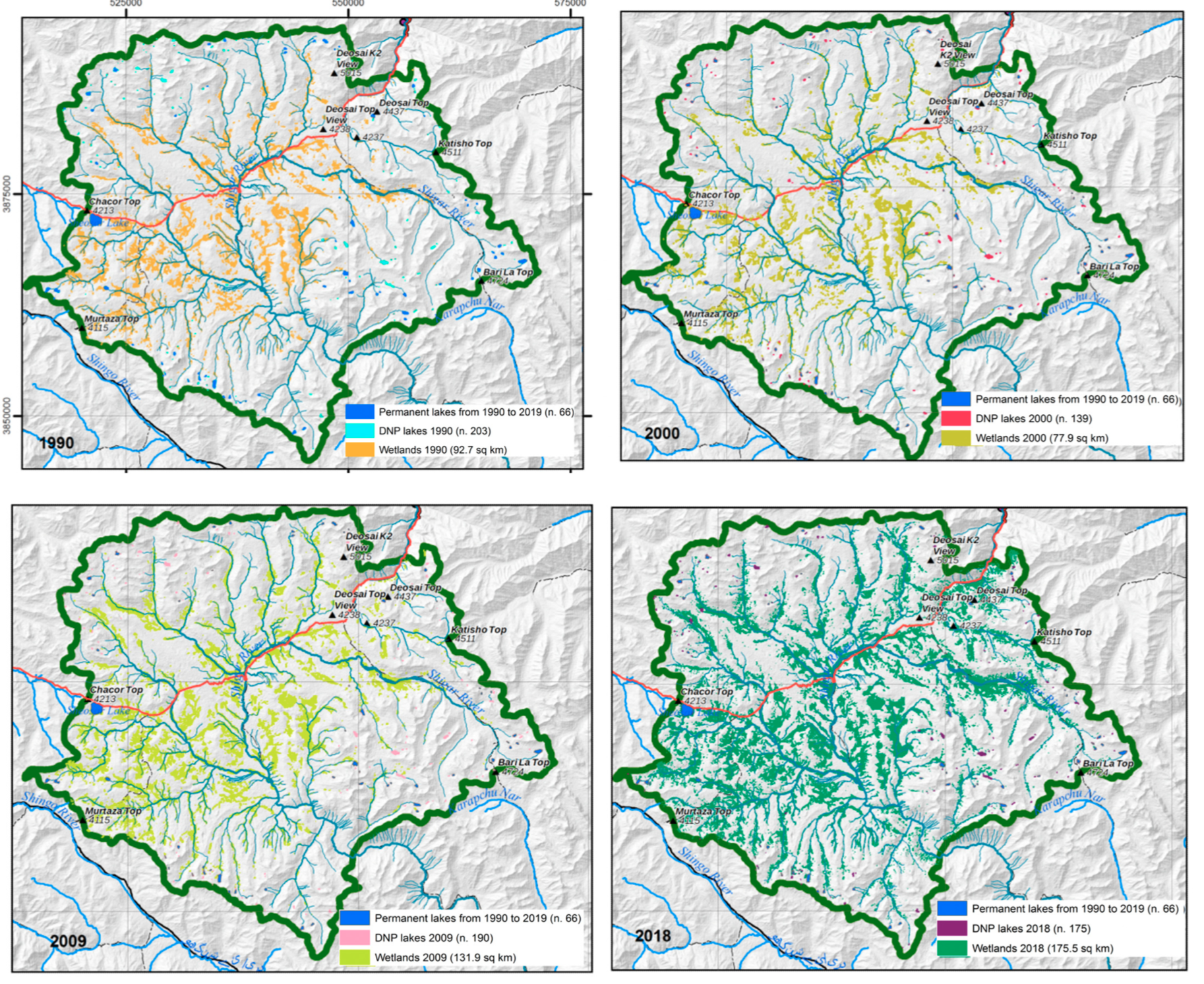
In this map, the extraction of lakes and wetlands from the time-series analysis of Landsat imagery returned. Four maps, referred to the four years 1990, 259 1000, 2009 and 2018 have been created to show the geographic distribution of the lakes a 260 and wetlands in the different time. It can be seen that 66 lakes can be considered permanent in the range of the considered forty years, as they were present in each of the 13 images from 1990 to 2019. Moreover, in the maps, the number of lakes in the year of ref- 263 erence are displayed: 203 in 1990, 139 in 2000, 190 in 2009, and 175 in 2018. The number and surfaces of the lakes have been analysed in the GIS environment extracting the following information: • 66 lakes are permanent from 1990; • The number and the total surface of the small lakes show a gentle decrease from 1990 toward 2019; • The surface of the wetlands shows a clear increasing in the considered interval. These results are published as: Melis, M.T.; Dessì, F.G.; Casu, M. New Remote Sensing Data on the Potential Presence of Permafrost in the Deosai Plateau in the Himalayan Portion of Pakistan. Remote Sens. 2023, 15, 1800. https://doi.org/10.3390/rs15071800
-
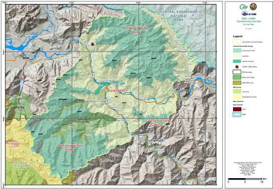
The study of the DNP Management Plan proposed the recognition of a corridor between the DNP and CKNP. In the map, this proposed
-
in the DNP, a network of touristic trails is delineated connecting some relevant points and hotspots. The idea is to offer the tourists that spend a night inside the Park some opportunities to enjoy the Deosai plateau beauty without disturbing the wildlife and the environment, in a sustainable way. The rules for these trails are: • Starting from the campsites • Only inside the Sustainable Use Zone • Connecting the Park with the Corridor • Only by feet • Camping allowed only in the delineated areas • Take-back system for waste management (no bins) The main trails are: • Sheosar Lake tour • Wildlife Watch Tower • K2 view Point cross to Satpara • Trails connected with the Corridor area to the villages of Shilla and Dappa
-
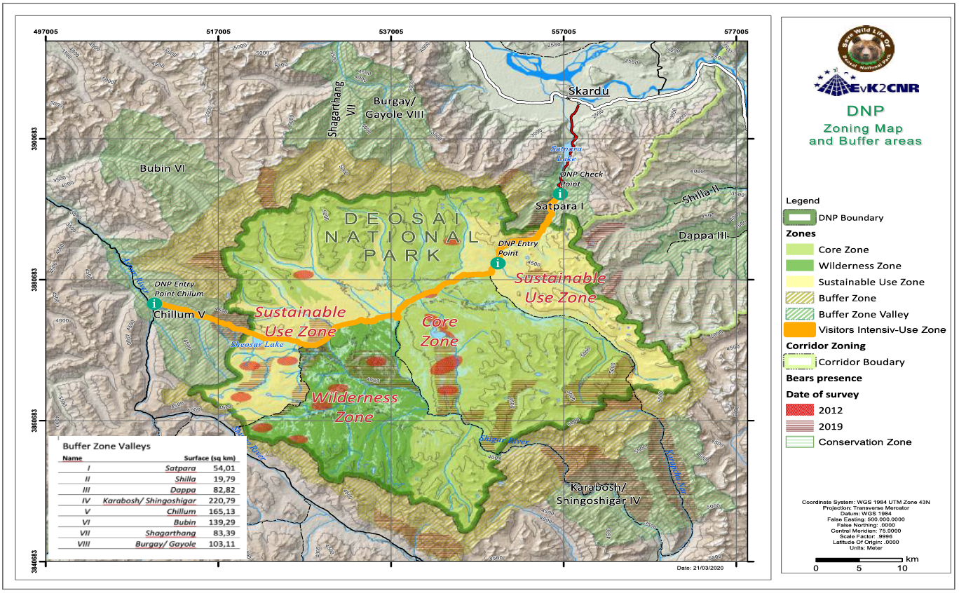
The zoning exercise conducted for DNP aimed to balance use and conservation, keeping conservation as a priority; however, without compromising the sustainable use of the Park. The use includes that allowed under the legislation, namely recreation and education, and traditional rights of the local communities and the Gujjar-Bakarwals that are dependent on the DNP. The Deosai National Park is designated as “National Park” under the wildlife legislation. However, to allow for development of tailored management principles for different areas within the DNP designated zones, their purpose, and broad management guidelines are described in this chapter: there are four different zones inside the Park Boundaries and two zones outside the park in a comprehensive Buffer Zone. • Core Zone • Wilderness Zone • Sustainable Use Zone • Visitors Intensive-Use Zone Outside the Park boundaries: • Buffer Zone • Buffer Zone Valleys
-

In the framework of the project “Improvement of Central Karakoram National Park Management System as Model for Mountain Ecosystems in Northern Pakistan”, basic and thematic cartography of the area of Deosai National Park, in the province of Gilgit Baltistan in Pakistan has been realized. The project, funded by UNDP (United Nations Development Program), sees the participation of the UNICA – Department of Chemical and Geological Sciences of the University of Cagliari, in support of the activities of the EvK2-CNR Recognized Association, on two main themes: – Basic and thematic cartography of the area of Deosai National Park, in the province of Gilgit Baltistan in Pakistan; – Update and reactivation of web publishing services of EvK2-SHAREGeoNetwork system data dedicated to data collected by high altitude stations (Himalaya – Karakorum) already present in the DB and to the data that will be collected in the field during this project. The laboratory activities that mainly concern the realignment of existing databases, satellite data processing and the development of a mobile application for data collection and sharing, will be accompanied by field surveys and by the support of local technicians with theoretical and practical training sessions for data collection and management of web sharing systems. The training activities will take place in the field and at the universities of Gilgit and Skardu, where days will be organized to involve local technicians and students.