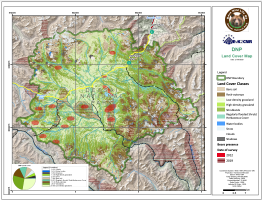
Land cover map of the Deosai National Park
The Land Cover of the DNP map has been obtained from ESA Sentinel-2 imagery.
The image used for the interpretation and final classification has been chosen on the basis of phenological state of the vegetation and cloud cover percentage. Moreover, in areas without deciduous vegetation or major seasonal crop variations, one month might suffice. Considering these conditions, a single multispectral image acquired on August 06 2018 has been used.
In order to classify the remote sensing image (Sentinel-2), a supervised classification approach using the maximum likelihood (ML) classification algorithm was applied. MLC is a widely used pixel-based, parametric classifier based on the Bayes theorem. It makes use of a discriminant function to assign pixel to the class with the highest likelihood.
|
|
Citation proposal
. Land cover map of the Deosai National Park. https://geoportal.mountaingenius.org/geonetwork/srv/api/records/da2a4fe5-d06a-42d5-83c0-6c82a1de79f4 |
INSPIRE
Identification
- File identifier
- da2a4fe5-d06a-42d5-83c0-6c82a1de79f4 XML
Online resource
- Protocol
- WWW:DOWNLOAD-1.0-http--download
Resource identifier
- Metadata language
- English
- Spatial representation type
- Vector
Encoding
Projection
- code
- WGS 1984
Classification of data and services
Classification of data and services
Coupled resource
Coupled resource
Classification of data and services
Coupled resource
Coupled resource
Keywords
Other keywords
- Keywords ( Theme )
-
- Maps , Thematic cartography , Remote sensing
- Keywords ( Place )
-
- Deosai , Pakistan , Baltistan
Geographic coverage
))
Temporal reference
Temporal extent
Temporal extent
- Date ( Publication )
Quality and validity
- Lineage
- Denominator
- 50000
Conformity
Conformity
Conformity
Conformity
Conformity
Conformity
Restrictions on access and use
- Access constraints
Restrictions on access and use
Responsible organization (s)
Contact for the resource
- Organisation name
- University of Cagliari/ EvK2CNR
- titimelis@unica.it
Responsible organization (s)
Contact for the resource
- Organisation name
- University of Cagliari/ EvK2CNR
- titimelis@unica.it
Metadata information
Contact for the metadata
- Organisation name
- University of Cagliari/ EvK2CNR
- titimelis@unica.it
- Date stamp
- 2026-01-19T17:32:10
- Metadata language
- English
- Character set
- UTF8
SDS
Conformance class 1: invocable
Access Point URL
Endpoint URL
Technical specification
Conformance class 2: interoperable
Coordinate reference system
Quality of Service
Access constraints
Limitation
Use constraints
Limitation
Responsible custodian
Contact for the resource
Conformance class 3: harmonized
Overviews
Provided by