
Hydrological Basins in Africa (Sample record, please remove!)
Major hydrological basins and their sub-basins. This dataset divides the African continent according to its hydrological characteristics.
The dataset consists of the following information:- numerical code and name of the major basin (MAJ_BAS and MAJ_NAME); - area of the major basin in square km (MAJ_AREA); - numerical code and name of the sub-basin (SUB_BAS and SUB_NAME); - area of the sub-basin in square km (SUB_AREA); - numerical code of the sub-basin towards which the sub-basin flows (TO_SUBBAS) (the codes -888 and -999 have been assigned respectively to internal sub-basins and to sub-basins draining into the sea)
|
|
Citation proposal
. Hydrological Basins in Africa (Sample record, please remove!). https://geoportal.mountaingenius.org/geonetwork/srv/api/records/da165110-88fd-11da-a88f-000d939bc5d8 |
INSPIRE
Identification
- File identifier
- da165110-88fd-11da-a88f-000d939bc5d8 XML
Online resource
- Protocol
- WWW:LINK-1.0-http--link
- Protocol
- WWW:DOWNLOAD-1.0-http--download
- Protocol
- OGC:WMS
Resource identifier
- Metadata language
- eng
- Spatial representation type
- Vector
Encoding
- Format
- ShapeFile
- Version
- Grass Version 6.1
Projection
- code
- WGS 1984
Classification of data and services
- Topic category
-
- Inland waters
Classification of data and services
Coupled resource
Coupled resource
Classification of data and services
Coupled resource
Coupled resource
Keywords
Other keywords
- Keywords ( Theme )
-
- watersheds , river basins , water resources , hydrology , AQUASTAT , AWRD
- Keywords ( Place )
-
- Africa
Geographic coverage
N
S
E
W
))
Temporal reference
Temporal extent
Temporal extent
- Date ( Creation )
- 2000-07-19T14:45:00
Quality and validity
- Lineage
- The linework of the map is obtained by delineating drainage basin boundaries from an hydrologically corrected digital elevation model with a resolution of 1 * 1 km.
- Denominator
- 5000000
Conformity
Conformity
Conformity
Conformity
Conformity
Conformity
Restrictions on access and use
- Use limitation
Restrictions on access and use
Responsible organization (s)
Contact for the resource
Responsible organization (s)
Contact for the resource
Metadata information
Contact for the metadata
- Organisation name
- FAO - NRCW
- jippe.hoogeveen@fao.org
- Date stamp
- 2007-11-06T12:13:00
- Metadata language
- eng
- Character set
- UTF8
SDS
Conformance class 1: invocable
Access Point URL
Endpoint URL
Technical specification
Conformance class 2: interoperable
Coordinate reference system
Quality of Service
Access constraints
Limitation
Use constraints
Limitation
Responsible custodian
Contact for the resource
Conformance class 3: harmonized
Overviews
Hydrological Basins in Africa (small preview)
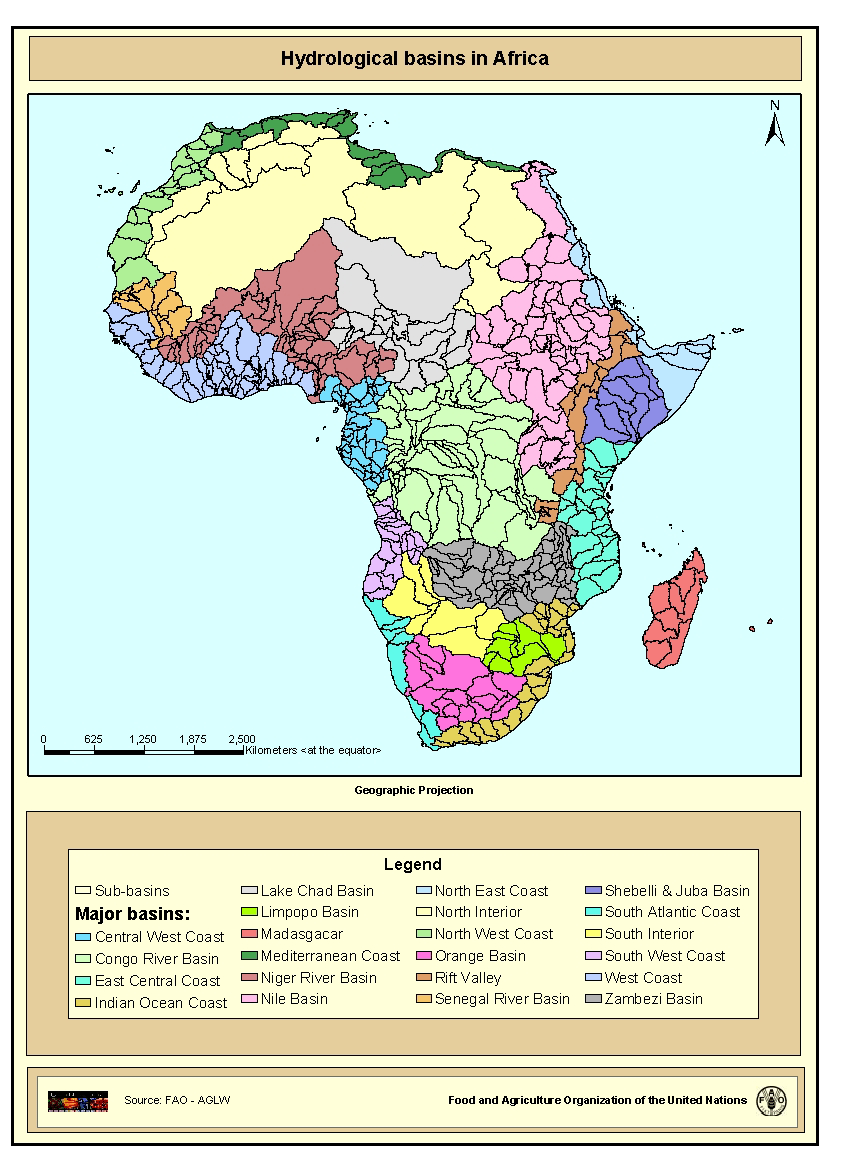
Hydrological Basins in Africa
Provided by

Views
da165110-88fd-11da-a88f-000d939bc5d8
Access to the portal
Read here the full details and access to the data.
Associated resources
Not available