Deosai National Park - Diachronic Analysis of Water bodies and Wetlands
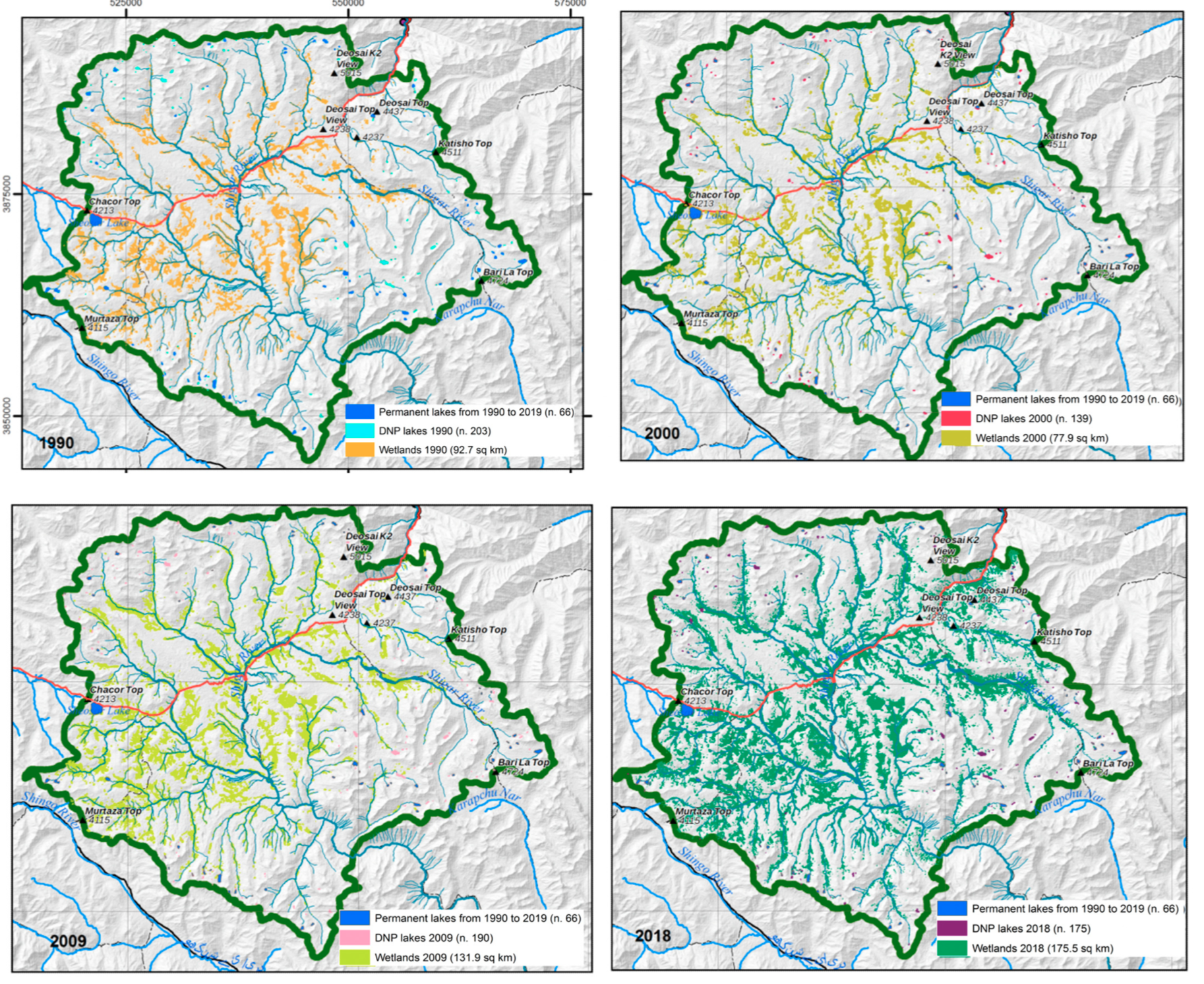
In this map, the extraction of lakes and wetlands from the time-series analysis of Landsat imagery returned. Four maps, referred to the four years 1990, 259 1000, 2009 and 2018 have been created to show the geographic distribution of the lakes a 260 and wetlands in the different time. It can be seen that 66 lakes can be considered permanent in the range of the considered forty years, as they were present in each of the 13 images from 1990 to 2019. Moreover, in the maps, the number of lakes in the year of ref- 263 erence are displayed: 203 in 1990, 139 in 2000, 190 in 2009, and 175 in 2018. The number and surfaces of the lakes have been analysed in the GIS environment extracting the following information:
• 66 lakes are permanent from 1990;
• The number and the total surface of the small lakes show a gentle decrease from 1990 toward 2019;
• The surface of the wetlands shows a clear increasing in the considered interval.
These results are published as:
Melis, M.T.; Dessì, F.G.; Casu, M. New Remote Sensing Data on the Potential Presence of Permafrost in the Deosai Plateau in the Himalayan Portion of Pakistan. Remote Sens. 2023, 15, 1800. https://doi.org/10.3390/rs15071800
|
|
Citation proposal
. Deosai National Park - Diachronic Analysis of Water bodies and Wetlands. https://geoportal.mountaingenius.org/geonetwork/srv/api/records/95d12f4f-1fc9-45e9-ba36-402aae3aa67d |
- Identification
- Distribution
- Quality
- Spatial rep.
- Ref. system
- Content
- Portrayal
- Metadata
- Md. constraints
- Md. maintenance
- Schema info
Identification
Data identification
Citation
- Date ( Publication )
- Edition
- Purpose
- Status
- Completed
- Maintenance and update frequency
- As needed
- Keywords ( Theme )
-
- Maps , Thematic cartography , Remote sensing
- Keywords ( Place )
-
- Deosai , Pakistan , Baltistan
Legal constraints
- Access constraints
- Copyright
- Use constraints
- otherRestictions
- Other constraints
- Spatial representation type
- Vector
- Denominator
- 50000
- Metadata language
- English
- Character set
- UTF8
))
Distribution
Distribution
- Distribution format
- OnLine resource
- remotesensing-15-01800.pdf
Quality
Data quality
- Hierarchy level
- Dataset
Ref. system
- Reference system identifier
- WGS 1984
Metadata
Metadata
- File identifier
- 95d12f4f-1fc9-45e9-ba36-402aae3aa67d XML
- Metadata language
- English
- Character set
- UTF8
- Parent identifier
- 73aba370-0fbf-4217-9fee-e00e9524db67
- Date stamp
- 2024-04-12T15:27:24
- Metadata standard name
- ISO 19115:2003/19139
- Metadata standard version
- 1.0
Point of contact
Overviews
Provided by