
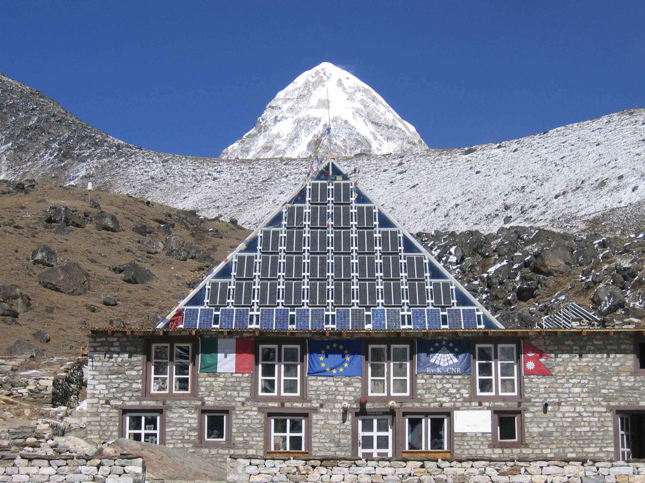
Pyramid International Laboratory-Observatory (Lobuche, Khumbu Valley, Himalaya - Nepal)
The laboratory was installed and became operational in September 1990. Not only did the Pyramid soon become a fundamental scientific outpost for researchers and technicians, but it also grew to be known as a point of reference for local populations and tourists who could take advantage of the advanced telecommunications systems available there to send urgent messages to Kathmandu or abroad.
The Pyramid International Laboratory - Observatory was officially inaugurated in October or 1990, by the Prime Minister of Nepal, a RONAST officer, the Italian Ambassador in Kathmandu, Agostino Da Polenza and the incredible Ardito Desio, who, at the age of 93, would not miss the historic occasion, making the trip personally to the Pyramid's 5,050 meters a.s.l.
The facility is operated by the Ev-K2-CNR and the Nepal Academy of Science and Technology. Their partnership has given rise to 520 scientific missions with the participation of 220 researchers and 143 different international scientific institutions.
The independent lodge is made in the style of Nepalese lodge architecture and can host up to 20 researchers, technicians and logistics staff.
In the Khumbu Valley, located in the central part of the Himalayan range and including the area of Sagarmatha National Park, a network of 7 Automatic Weather Station (AWSs) has been installed since 1994.
These weather stations are located at different altitudes: Lukla (2,660 m a.s.l), Namche (3,570 m a.s.l), Periche (4,260 m a.s.l), Lobuche (5,050 m a.s.l) near the Pyramid Laboratory - Observatory, Kala Patthar (5,600 m a.s.l), Changri Nup Glacier (5,700 m a.s.l) and Mt. Everest - South Col (8.000 m a.s.l).
The network mainly takes measurements of 7 standards parameters: air temperature, relative humidity, atmospheric pressure, wind speed and direction, global radiation and total precipitation.
Meteo-climatic observations in this area are very important to better understand the environmental changes that are affecting the ecosystem, helping the scientific community to improve the prediction of this environmental phenomena’s evolution and modification.
On 2004, the Pyramid AWS has been implemented to include sensors for the determination of soil parameters (temperature, water content, thermal flux), snow level and shortwave/longwave albedo.
Geographical coordinates:
Latitude: 27° 57' 32" N
Longitude: 86° 48' 46" E
|
|
Citation proposal
(2014) . Pyramid International Laboratory-Observatory (Lobuche, Khumbu Valley, Himalaya - Nepal). https://geoportal.mountaingenius.org/geonetwork/srv/api/records/8f278c1b-1eb8-47be-9a0a-a7429c23dd9c |
Simple
- Date ( Publication )
- 2014-09-02T19:08:00
- Edition
- Purpose
-
The Pyramid AWS provides data (with a 60 minute time resolution) of the following parameters:
- station pressure (hPa)
- air temperature (°C)
- relative humidity (%)
- wind speed (m/s)
- wind direction (degree)
- global solar radiation (W/m2)
- total precipitation (mm)
Since 2004 this station has been measuring also the following parameters:
- snow depth (m)
- incoming shortwave radiation (W/m2)
- outgoing shortwave radiation (W/m2)
- incoming longwave radiation (W/m2)
- outgoing longwave radiation (W/m2)
- soil heat flux (W/m2)
- soil temperature (°C)
- soil moisture (%)
- Status
- Completed
Point of contact
- Maintenance and update frequency
- As needed
- Keywords ( Theme )
-
- SHARE , monitoring network , station, Pyramid International Laboratory - Observatory , NEXTDATA
- Keywords ( Place )
-
- Nepal , Lobuche , Khumbu Valley , Sagarmatha National Park
- Use limitation
- Data Sharing and Publication Policy at DISTRIBUTION SECTION
- Access constraints
- Intellectual property rights
- Other constraints
- Spatial representation type
- Vector
- Character set
- UTF8
- Topic category
-
- Climatology, meteorology, atmosphere
- Geoscientific information
- Environment
))
- Reference system identifier
- EPSG / WGS 84 (EPSG:4326) / 7.4
- Topology level
- Geometry only
- Geometric object type
- Point
- Geometric object count
- 1
- OnLine resource
-
View in Google Earth
View in Google Earth
- OnLine resource
- Data Usage Policy
- Hierarchy level
- Series
- Statement
-
The automatic weather stations (AWS) for monitor meteorological conditions are currently included in the SHARE network.
An automatic weather station (AWS) is defined as a “meteorological station at which observations are made and transmitted automatically” (WMO, 1992a).
In particular, in the framework of the SHARE project for all parameters, the data has been visually checked, looking for extremely and unusual low/high values and/or periods with constant values.
gmd:MD_Metadata
- File identifier
- 8f278c1b-1eb8-47be-9a0a-a7429c23dd9c XML
- Metadata language
- eng
- Character set
- UTF8
- Parent identifier
- 64f00741-0a95-4da1-bad0-943ba71164df
- Hierarchy level
- Series
- Hierarchy level name
- Date stamp
- 2025-01-18T19:04:05
- Metadata standard name
- ISO 19115:2003/19139
- Metadata standard version
- 1.0
Point of contact
- Dataset URI
Overviews
Provided by
