
Physiographic Map of North and Central Eurasia (Sample record, please remove!)
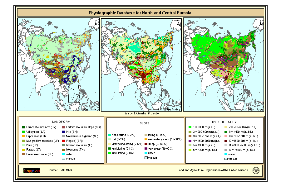
Physiographic maps for the CIS and Baltic States (CIS_BS), Mongolia, China and Taiwan Province of China. Between the three regions (China, Mongolia, and CIS_BS countries) DCW boundaries were introduced. There are no DCW boundaries between Russian Federation and the rest of the new countries of the CIS_BS. The original physiographic map of China includes the Chinese border between India and China, which extends beyond the Indian border line, and the South China Sea islands (no physiographic information is present for islands in the South China Sea). The use of these country boundaries does not imply the expression of any opinion whatsoever on the part of FAO concerning the legal or constitutional states of any country, territory, or sea area, or concerning delimitation of frontiers. The Maps visualize the items LANDF, HYPSO, SLOPE that correspond to Landform, Hypsometry and Slope.
|
|
Citation proposal
(1999) . Physiographic Map of North and Central Eurasia (Sample record, please remove!). https://geoportal.mountaingenius.org/geonetwork/srv/api/records/78f93047-74f8-4419-ac3d-fc62e4b0477b |
Simple
- Date ( Publication )
- 1999-10-01
- Edition
- First
- Presentation form
- Digital map
- Purpose
- Status
- Completed
Point of contact
FAO - Land and Water Development Division
-
Nachtergaele Freddy
(Technical officer )
Viale delle Terme di Caracalla
Rome
RM
00153
Italy
- Maintenance and update frequency
- As needed
- Keywords ( Theme )
-
- physiography, soil
- Keywords ( Place )
-
- Eurasia
- Access constraints
- Copyright
- Use constraints
- Copyright
- Other constraints
- Spatial representation type
- Vector
- Denominator
- 5000000
- Metadata language
- Character set
- UTF8
- Topic category
-
- Geoscientific information
- Time period
- 2000-01-01T04:29:002008-01-08T04:29:00
N
S
E
W
))
- Supplemental Information
- The maps are included in the SOIL and TERRAIN Database for Northern and Central EURASIA CD-ROM , which contains also the Soil map of North and Central Eurasia, reports and databases. Copies of this CD-Rom can be ordered from: Sales and Marketing Group FAO, Viale delle Terme di Caracalla, 00153 Rome, or by email to Publications-sales@fao.org. The terms and definitions used in the Physiographic database are based on the procedures manual for ?Global and National Soils and Terrain Digital Databases (SOTER)?, prepared by UNEP, ISSS, ISRIC and FAO and published by FAO as World Soil Resources Report #74 Rev1 (1995). Refinements were made in China as part of the preparation of a physiographic map for Asia, work carried out by G. van Lynden for FAO as part of the ASSOD project.
- Reference system identifier
- Lambert Azimuthal Projection
- Topology level
- Abstract
- Geometric object type
- Complex
- OnLine resource
-
phy.zip
Physiography of North and Central Eurasia Landform (Gif Format)
- OnLine resource
-
GEONETWORK:phy_landf_7386
Physiography of North and Central Eurasia Landform
- OnLine resource
-
GEONETWORK:phy_slope_7386
Physiography of North and Central Eurasia Slope
- OnLine resource
-
GEONETWORK:phy_hypso_7386
Physiography of North and Central Eurasia Hypsography
- Hierarchy level
- Dataset
- Statement
gmd:MD_Metadata
- File identifier
- 78f93047-74f8-4419-ac3d-fc62e4b0477b XML
- Metadata language
- Character set
- UTF8
- Date stamp
- 2007-11-06T12:10:47
- Metadata standard name
- ISO 19115:2003/19139
- Metadata standard version
- 1.0
Overviews
Physiographic Map (small preview)
Physiographic Map
Provided by

Views
78f93047-74f8-4419-ac3d-fc62e4b0477b
Access to the portal
Read here the full details and access to the data.
Associated resources
Not available