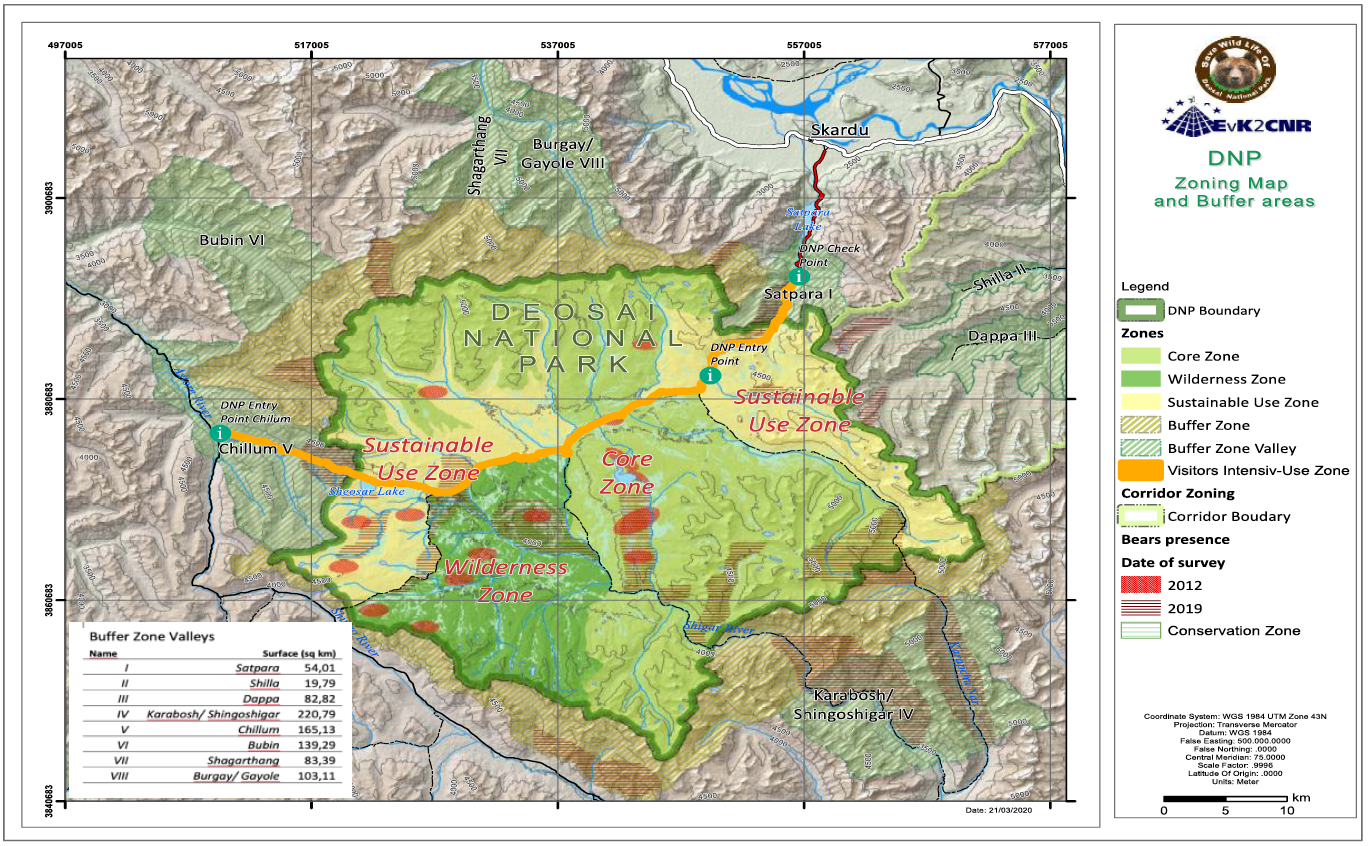
Deosai National Park Zoning map and buffer areas
The zoning exercise conducted for DNP aimed to balance use and conservation, keeping conservation as a priority; however, without compromising the sustainable use of the Park. The use includes that allowed under the legislation, namely recreation and education, and traditional rights of the local communities and the Gujjar-Bakarwals that are dependent on the DNP.
The Deosai National Park is designated as “National Park” under the wildlife legislation. However, to allow for development of tailored management principles for different areas within the DNP designated zones, their purpose, and broad management guidelines are described in this chapter: there are four different zones inside the Park Boundaries and two zones outside the park in a comprehensive Buffer Zone.
• Core Zone
• Wilderness Zone
• Sustainable Use Zone
• Visitors Intensive-Use Zone
Outside the Park boundaries:
• Buffer Zone
• Buffer Zone Valleys
|
|
Citation proposal
. Deosai National Park Zoning map and buffer areas. https://geoportal.mountaingenius.org/geonetwork/srv/api/records/337aa3a6-7870-4765-8426-ff7b5dc065d2 |
- Identification
- Distribution
- Quality
- Spatial rep.
- Ref. system
- Content
- Portrayal
- Metadata
- Md. constraints
- Md. maintenance
- Schema info
Identification
Data identification
Citation
- Date ( Publication )
- Edition
- Purpose
- Status
- Completed
- Maintenance and update frequency
- As needed
- Keywords ( Theme )
-
- Maps , Thematic cartography , Remote sensing
- Keywords ( Place )
-
- Deosai , Pakistan , Baltistan
Legal constraints
- Access constraints
- Copyright
- Use constraints
- otherRestictions
- Other constraints
- Spatial representation type
- Vector
- Denominator
- 50000
- Metadata language
- English
- Character set
- UTF8
))
Distribution
- OnLine resource
-
Progetto_DEOSAI_08_03_2020_mappa_zoning_Deosai_A5_3.pdf
Download the map
Quality
Data quality
- Hierarchy level
- Dataset
- Statement
Ref. system
- Reference system identifier
- WGS 1984
Metadata
Metadata
- File identifier
- 337aa3a6-7870-4765-8426-ff7b5dc065d2 XML
- Metadata language
- English
- Character set
- UTF8
- Parent identifier
- 73aba370-0fbf-4217-9fee-e00e9524db67
- Date stamp
- 2026-01-19T17:27:22
- Metadata standard name
- ISO 19115:2003/19139
- Metadata standard version
- 1.0
Point of contact
Overviews
Provided by