Central Karakorum National Park valleys: Land Cover maps of each valley
The Central Karakorum National Park (CKNP) is one of the most important national parks of Pakistan and comprises one of the largest mountain glacial systems in the world with Siachen (75 km), Baltoro (57 km) and Hispar-Biafo (122 km) glaciers originating within its boundaries. Administratively, it is situated in the Skardu and Gilgit districts of the Gilgit and Baltistan Region of Pakistan.
The 72,500 km2 national park borders China, Afghanistan, and India, and represents one section of the of Hindu Kush-Karakorum-Himalaya mountain range.
The area is part of the "transitional zone" between the arid Central Asia and the semi-humid subtropics of the northern South Asia.
The land cover map for the CKNP has been divided into 14 subregions as follows:
- Astak
- Bagrot
- Basha
- Daghoni
- Danyore
- Ghulmat
- Haramosh
- Hopper
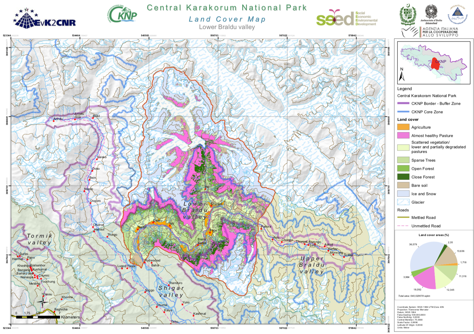
- Lower Braldu
- Nagar
- Shigar
- Thalay
- Tormik
- Upper Braldu
|
|
Citation proposal
. Central Karakorum National Park valleys: Land Cover maps of each valley. https://geoportal.mountaingenius.org/geonetwork/srv/api/records/0ef39cf1-81ca-4baa-84c9-f53b7942e8b4 |
INSPIRE
Identification
- File identifier
- 0ef39cf1-81ca-4baa-84c9-f53b7942e8b4 XML
Online resource
- Protocol
- WWW:DOWNLOAD-1.0-http--download
- Protocol
- WWW:DOWNLOAD-1.0-http--download
- Protocol
- WWW:DOWNLOAD-1.0-http--download
- Protocol
- WWW:DOWNLOAD-1.0-http--download
- Protocol
- WWW:DOWNLOAD-1.0-http--download
- Protocol
- WWW:DOWNLOAD-1.0-http--download
- Protocol
- WWW:DOWNLOAD-1.0-http--download
- Protocol
- WWW:DOWNLOAD-1.0-http--download
- Protocol
- WWW:DOWNLOAD-1.0-http--download
- Protocol
- WWW:DOWNLOAD-1.0-http--download
- Protocol
- WWW:DOWNLOAD-1.0-http--download
- Protocol
- WWW:DOWNLOAD-1.0-http--download
- Protocol
- WWW:DOWNLOAD-1.0-http--download
- Protocol
- WWW:DOWNLOAD-1.0-http--download
- Protocol
- WWW:DOWNLOAD-1.0-http--download
Resource identifier
- Metadata language
- English
- Spatial representation type
- Vector
Encoding
Projection
- code
- WGS 1984
Classification of data and services
- Topic category
-
- Boundaries
Classification of data and services
Coupled resource
Coupled resource
Classification of data and services
Coupled resource
Coupled resource
Keywords
Other keywords
- Keywords ( Theme )
-
- Keywords ( Place )
-
- Pakistan , CKNP , Central Karakorum National Park
- Keywords
-
- Land cover , Remote sensing
Geographic coverage
))
Temporal reference
Temporal extent
Temporal extent
- Date ( Publication )
Quality and validity
- Lineage
- Denominator
- 100000
Conformity
Conformity
Conformity
Conformity
Conformity
Conformity
Restrictions on access and use
- Access constraints
Restrictions on access and use
Responsible organization (s)
Contact for the resource
- Organisation name
- University of Cagliari/EvK2CNR
- titimelis@unica.it
Responsible organization (s)
Contact for the resource
- Organisation name
- University of Cagliari/EvK2CNR
- titimelis@unica.it
Metadata information
Contact for the metadata
- Organisation name
- University of Cagliari
- titimelis@unica.it
- Date stamp
- 2025-02-10T13:43:30
- Metadata language
- English
- Character set
- UTF8
SDS
Conformance class 1: invocable
Access Point URL
Endpoint URL
Technical specification
Conformance class 2: interoperable
Coordinate reference system
Quality of Service
Access constraints
Limitation
Use constraints
Limitation
Responsible custodian
Contact for the resource
Conformance class 3: harmonized
Overviews
Provided by