Central Karakorum National Park valleys: Land Cover maps of each valley
The Central Karakorum National Park (CKNP) is one of the most important national parks of Pakistan and comprises one of the largest mountain glacial systems in the world with Siachen (75 km), Baltoro (57 km) and Hispar-Biafo (122 km) glaciers originating within its boundaries. Administratively, it is situated in the Skardu and Gilgit districts of the Gilgit and Baltistan Region of Pakistan.
The 72,500 km2 national park borders China, Afghanistan, and India, and represents one section of the of Hindu Kush-Karakorum-Himalaya mountain range.
The area is part of the "transitional zone" between the arid Central Asia and the semi-humid subtropics of the northern South Asia.
The land cover map for the CKNP has been divided into 14 subregions as follows:
- Astak
- Bagrot
- Basha
- Daghoni
- Danyore
- Ghulmat
- Haramosh
- Hopper
- Lower Braldu
- Nagar
- Shigar
- Thalay
- Tormik
- Upper Braldu
|
|
Citation proposal
. Central Karakorum National Park valleys: Land Cover maps of each valley. https://geoportal.mountaingenius.org/geonetwork/srv/api/records/0ef39cf1-81ca-4baa-84c9-f53b7942e8b4 |
- Identification
- Distribution
- Quality
- Spatial rep.
- Ref. system
- Content
- Portrayal
- Metadata
- Md. constraints
- Md. maintenance
- Schema info
Identification
Data identification
Citation
- Date ( Publication )
- Purpose
- Status
- Completed
- Maintenance and update frequency
- As needed
- Keywords ( Theme )
-
- Keywords ( Place )
-
- Pakistan , CKNP , Central Karakorum National Park
- Keywords
-
- Land cover , Remote sensing
Legal constraints
- Access constraints
- Copyright
- Use constraints
- otherRestictions
- Other constraints
- Spatial representation type
- Vector
- Denominator
- 100000
- Metadata language
- English
- Character set
- UTF8
- Topic category
-
- Boundaries
))
Distribution
Digital transfer options
- OnLine resource
-
ASTAK_lc_15.pdf
Download ASTAK land cover map
- OnLine resource
-
BAGROT_lc_15.pdf
Download BAGROT land cover map
- OnLine resource
-
BASHA_lc.pdf
Download BASHA land cover map
- OnLine resource
-
DAGHONI_lc.pdf
Download DAGHONI land cover map
- OnLine resource
-
DANYORE_lc.pdf
Download DANYORE land cover map
- OnLine resource
-
GHULMAT_lc.pdf
Download GHULMAT land cover map
- OnLine resource
-
HARAMOSH_lc.pdf
Download HARAMOSH land cover map
- OnLine resource
-
HOPPER_lc.pdf
Download HOPPER land cover map
- OnLine resource
-
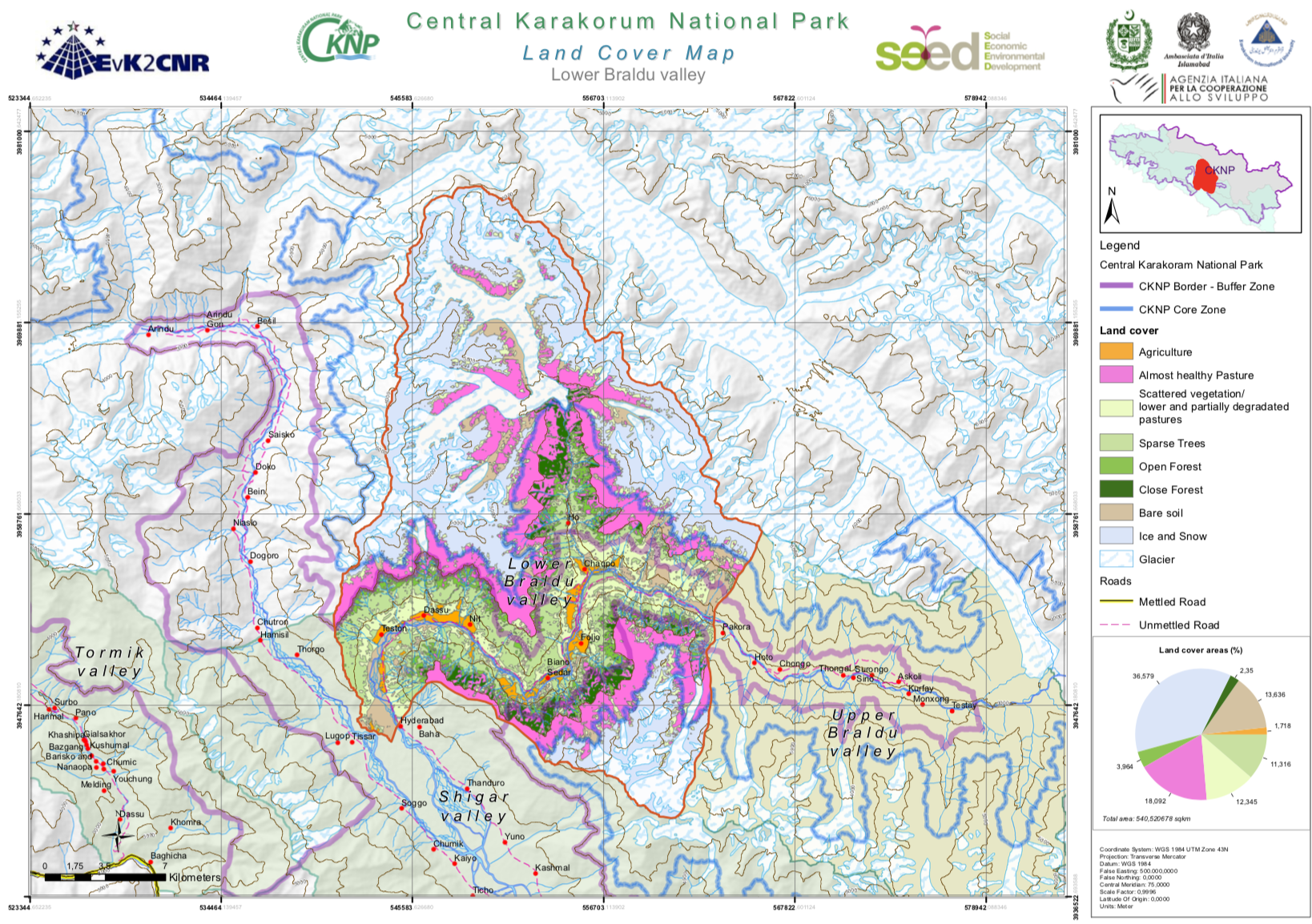
LOWER_BRALDU_lc.pdf
Download LOWER BRALDU land cover map
- OnLine resource
-
NAGAR_lc.pdf
Download NAGAR land cover map
- OnLine resource
-
SHIGAR_lc.pdf
Download SHIGAR land cover map
- OnLine resource
-
THALAY_lc.pdf
Download THALAY land cover map
- OnLine resource
-
TORMIK_lc.pdf
Download TORMIK land cover map
- OnLine resource
-
UPPER_BRALDU_lc.pdf
Download UPPER BRALDU land cover map
Quality
Data quality
- Hierarchy level
- Dataset
- Statement
Ref. system
- Reference system identifier
- WGS 1984
Metadata
Metadata
- File identifier
- 0ef39cf1-81ca-4baa-84c9-f53b7942e8b4 XML
- Metadata language
- English
- Character set
- UTF8
- Parent identifier
- 39d2ad1c-4c80-40db-82b3-a81605a303c6
- Date stamp
- 2025-02-10T13:43:30
- Metadata standard name
- ISO 19115:2003/19139
- Metadata standard version
- 1.0
Point of contact
Overviews
Provided by